In a Place that Doesn’t Exist… The Crash of TWA Flight 514 Near Mount Weather, Virginia December 1st, 1974 Federal Land...
 Mount Weather started its service to the United States near the turn of the Twentieth century – the site of a National Weather Bureau facility where balloons and box kites were sent up to observe weather conditions. In February of 1929, President Calvin Coolidge expressed interest in converting the buildings of Mount Weather Observatory to a summer White House. But the next President, Herbert Hoover, nixed the idea - preferring instead to use the presidential yacht, the Mayflower, to relax. Mount Weather started its service to the United States near the turn of the Twentieth century – the site of a National Weather Bureau facility where balloons and box kites were sent up to observe weather conditions. In February of 1929, President Calvin Coolidge expressed interest in converting the buildings of Mount Weather Observatory to a summer White House. But the next President, Herbert Hoover, nixed the idea - preferring instead to use the presidential yacht, the Mayflower, to relax.
In 1936, it came under the control of the U.S. Bureau of Mines, which began to dig an experimental mine into the mountain 100 yards below the surface along an east-west axis. The tunnel, which extended a scant quarter-mile and measured 7 ft. wide by 6 1/2 ft. high, provided the opening for what would, in 1954, be expanded by the Army Corps of Engineers under the code name ‘Operation High Point.’ Tunnel roofs are shored up with some 21,000 iron bolts driven 8 to 10 feet into the overhead rock. The entrance is protected by a guillotine gate, and a 10 foot tall by 20 foot wide 34-ton blast door that is 5 feet thick and reportedly takes 10 to 15 minutes to open or close, all leading into a massive underground complex of offices and living quarters.
Completed in 1958, the underground bunker includes a hospital, crematorium, dining and recreation areas, sleeping quarters, reservoirs of drinking and cooling water, an emergency power plant, and a radio and television studio which is part of the Emergency Broadcasting System. A series of side-tunnels accommodate a total of 20 office buildings, some of which are three stories tall, while an on-site 90,000 gallon/day sewage treatment plant and two 250,000 gallon above-ground storage tanks are intended to support a population of 200 for up to 30 days. Although the facility is designed to accommodate several thousand people (with sleeping cots for 2,000), only the President, the Cabinet, and Supreme Court are provided private sleeping quarters.
Established in 1959, and located in the Blue Ridge Mountains near Berryville, the Mount Weather Emergency Operations Center is a civilian command facility in Virginia, some 55 miles from Washington, D.C., and is used as the center of operations for the Federal Emergency Management Agency (FEMA).
Also known as the "High Point Special Facility", the facility has become a major relocation site for the highest level of civilian and military officials in case of national disaster, playing a major role in U.S. continuity of government (per the Continuity of Operations Plan), and also the location of a control station for the FEMA National Radio System, a high frequency radio system connecting most federal public safety agencies and U.S. military with most of the states. The only full-scale activation of the facility came on 9 November 1965, at the time of the great Northeastern power blackout.
The remoteness of the facility makes for limited access – only via Virginia State Route 601 (also called Blueridge Mountain Road) in Bluemont, Virginia. The road also provides utility services to the facility – its umbilical and only connection to the outside world. That, and the occasional aircraft that would cruise overhead.
December Skies…
Trans World Airlines Flight 514 departed from Indianapolis, Indiana, at 8:53 in the morning, bound for Washington-National Airport, DC (DCA), with an intermediate stop at Columbus-Port Columbus International Airport (CMH), Ohio. Arriving in Columbus at 09:32, the Boeing 727 – registered by N54328, powered by 3 Pratt & Whitney JT8D-9A and with 85 passengers and 7 flight crew members aboard – departed CMH at 10:24.
But, twelve minutes into the flight, at 10:36, the Cleveland Air Route Traffic Control Center (ARTCC) informed the crew of Flight 514 that no landings were being made at DCA because of high crosswinds, and that flights destined for that airport were either being held or being diverted to Dulles International Airport (IAD). The captain of Flight 514, Richard I. Brock, communicated with the dispatcher in New York and advised him of the information he had received.
Brock, 44, was hired by Trans World Airlines on December 5, 1955. He served as a flight engineer until March 1, 1967, when he qualified as first officer on the Convair 880. He qualified as first officer on the B-727 on June 19, 1969, and was upgraded to captain on the Boeing 727 on June 23, 1971. He was also qualified as a rated first officer on the Boeing 707.
The dispatcher, with Captain Brock's concurrence, subsequently amended Flight 514's release to allow the flight to proceed to Dulles. At 10:42, Cleveland ARTCC cleared Flight 514 to Dulles Airport via the Front Royal VOR, and to maintain FL290.
One minute later, the controller cleared the flight to descend to FL230 and to cross a point 40 miles west of Front Royal at that altitude. Air traffic control reasonability of the flight was then transferred to the Washington ARTCC and communications were established with that facility at 10:48. In the meantime, the flight crew: Captain Brock, his first officer Lenard W. Kresheck, and flight engineer Thomas C. Safranek, discussed the instrument approach to Runway 12, the navigational aids, and the runways at Dulles, and Brock turned the flight controls over to Kresheck, while the staff of four flight attendants - Denise A. Stander, 22, Jen A. Van Fossen, 22, Elizabeth H. (Stout) Martin, 23, and Joan E. Heady, 23 – served the passengers.
Amongst the 85 passengers aboard Flight 514 were U.S. Army Brigadier General Roscoe C. "Rock" Cartwright, 55, who had retired in September of 1974 after a 33-year military career, and his wife, Gloria. Also aboard was James Applewhite, a legislative assistant to Representative Andrew Young of Georgia, and Applewhite’s wife and their 3-year-old son.
When radio communications were established with Washington ARTCC, the controller on duty affirmed that he knew the flight was proceeding to Dulles. Following this, the flight crew of Flight 514 discussed the various routings they might receive to conduct a VOR/DME approach to Runway 12 at Dulles.
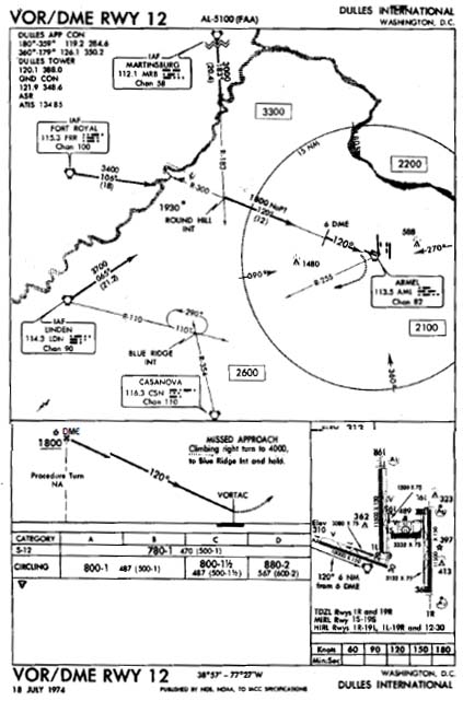 At 10:51, the Washington ARTCC controller requested the flight's heading. After being told that the flight was on a heading of 100 degrees, the controller cleared the crew to change to a heading of 090°, to intercept the 300° radial of the Armel VOR, to cross a point 25 miles northwest of Armel to maintain 8,000 feet, "...and the 300° radial will be for a VOR approach to runway 12 at Dulles." He gave the crew an altimeter setting of 29.74 inches for Dulles, which the crew acknowledged. After this, Brock and Kresheck continued to discuss the VOR/DME approach to Dulles. At 10:51, the Washington ARTCC controller requested the flight's heading. After being told that the flight was on a heading of 100 degrees, the controller cleared the crew to change to a heading of 090°, to intercept the 300° radial of the Armel VOR, to cross a point 25 miles northwest of Armel to maintain 8,000 feet, "...and the 300° radial will be for a VOR approach to runway 12 at Dulles." He gave the crew an altimeter setting of 29.74 inches for Dulles, which the crew acknowledged. After this, Brock and Kresheck continued to discuss the VOR/DME approach to Dulles.
At 10:55, the landing preliminary checklist was read by flight engineer Safranek and the other crewmembers responded to the calls. A reference speed of 127 knots was calculated and set on the airspeed indicator reference pointers. The altimeters were set at 29.74. The crew then again discussed items on the instrument approach chart including the Round Hill intersection, the final approach fix, the visual approach slope indicator and runway lights, and the airport diagram. At 10:59, Brock commented that the flight was descending from 11,000 feet to 8,000 feet. He then asked the controller if there were any weather obstructions between the flight and the airport. The controller replied that he did not see any significant weather along the route, and Brock replied that the crew also did not see any weather on the aircraft weather radar.
At 11:01, the controller cleared the flight to descend to and maintain 7,000 feet and to contact Dulles approach control. Twenty-six seconds later, Brock started a conversation with Dulles approach control and reported that the aircraft was descending from 10,000 feet to maintain 7,000 feet, and also reported having received the information "Charlie" transmitted on the ATIS broadcast. The controller, Merle W. Dameron, replied with a clearance to proceed inbound to Armel and to expect a VOR/DME approach to runway 12, and then also informed the crew that ATIS information “Delta” was current and read the data to them. The crew determined that the difference between information Charlie and Delta was the altimeter setting which was given in Delta as 29.70 inches. At 11:04, the flight reported it was level at 7,000 feet.
"Cleared for Approach"???
Five seconds after receiving that report, the controller said, "TWA 514, you're cleared for a VOR/DME approach to runway 12," which was acknowledged by Captain Brock. The Cockpit Voice Recorder (CVR) recorded the sound of the landing gear warning horn followed by a comment from Brock that "Eighteen hundred is the bottom."
Kresheck then said, "Start down."
Safranek said, "We're out here quite a ways. I better turn the heat down." At 11:05:06, the captain reviewed the field elevation, the minimum descent altitude, and the final approach fix and discussed the reason that no time to the missed approach point was published.
At 11:06:15, Kresheck commented that, "I hate the altitude jumping around. Then he commented that the instrument panel was bouncing around.
Brock countered, "We have a discrepancy in our VOR's, a little but not much." He continued, "Fly yours, not mine." At 11:06:27, Brock discussed the last reported ceiling and minimum descent altitude. concluded, "...should break out."
At 11:06:42, Kresheck said, "Gives you a headache after a while, watching this jumping around like that," and later, "...you can feel that wind down here now."
A few seconds later, Brock said, "You know, according to this dumb sheet it says thirtyfour hundred to Round Hill --- is our minimum altitude." The flight engineer then asked where the captain saw that and Brock replied, "Well, here. Round Hill is eleven and a half DME."
Kresheck said, "Well, but ---"
And Brock retorted, "When he clears you, that means you can go to your ---"
An unidentified voice said, "Initial approach”, and another unidentified voice said, "Yeah!"
Brock said "Initial approach altitude."
Safranek then said, "We're out a --- twenty-eight for eighteen."
An unidentified voice said, "Right, and someone said, "One to go."
At 11:08:14, Safranek said, "Dark in here."
Kresheck stated, "And bumpy too."
At 11:08:25, the sound of an altitude alert horn was recorded. Brock said, "I had ground contact a minute ago."
Kresheck replied, "Yeah, I did too."
At 11:08:29, the first officer said, "...power on this.... "
The captain said "Yeah --- you got a high sink rate."
"Yeah," the first officer replied.
An unidentified voice said, "We're going uphill," and Kresheck replied, "We're right there, we're on course."
Two voices responded, "Yeah!"
Captain Brock then said, "You ought to see ground outside in just a minute -- Hang in there boy."
Safranek said, "We're getting seasick."
At 1108:57, the altitude alert sounded. Then Safranek said, "Boy, it was --- wanted to go right down through there, man," to which an unidentified voice replied, "Yeah!"
Then Safranek said, "Must have had a hell of a downdraft."
At 1109:14, the radio altimeter warning horn sounded and stopped. Safranek said, "Boy!" By this point, the Boeing 727 was beginning to graze tree tops as it continued to descend downwards.
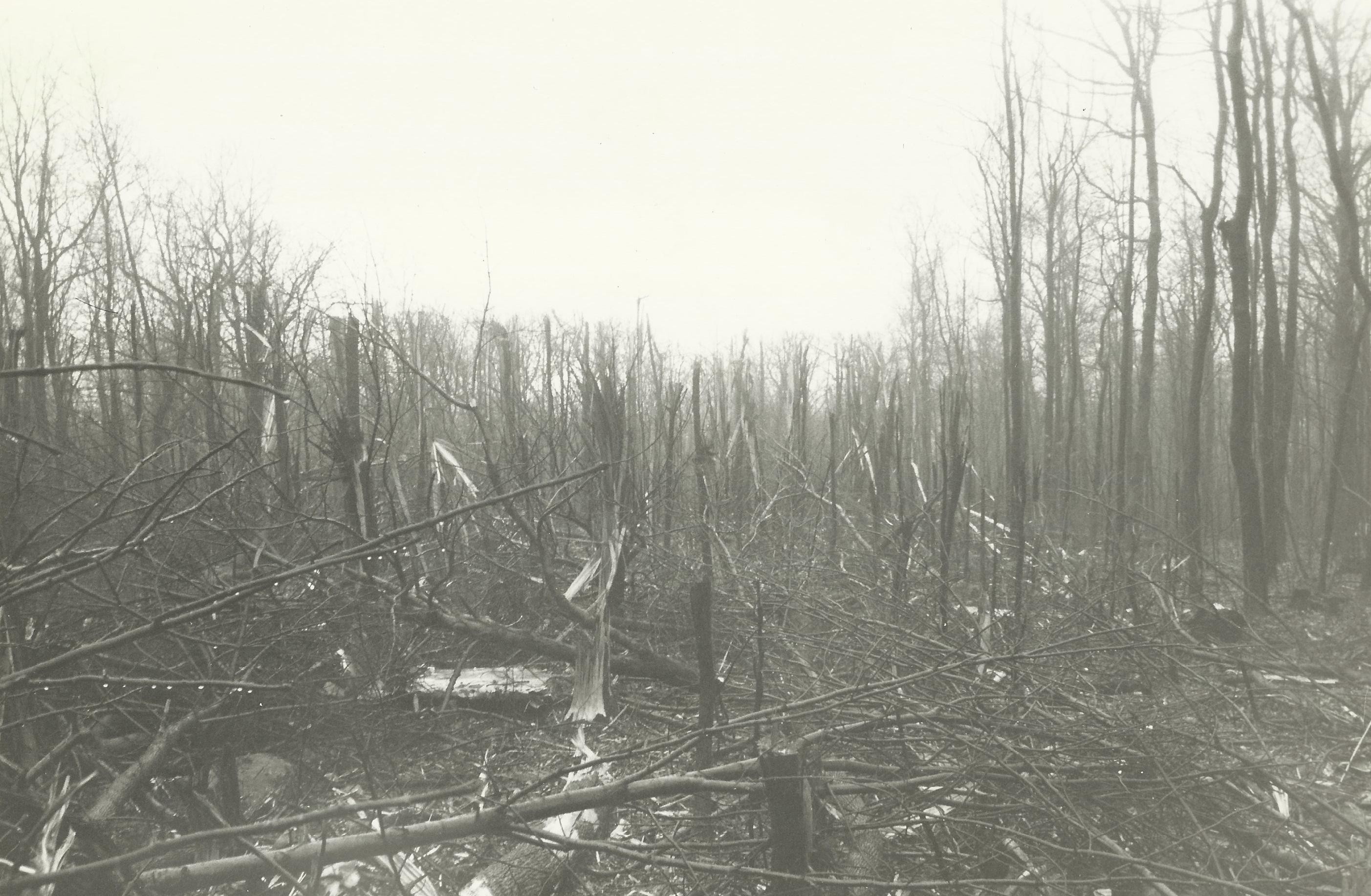
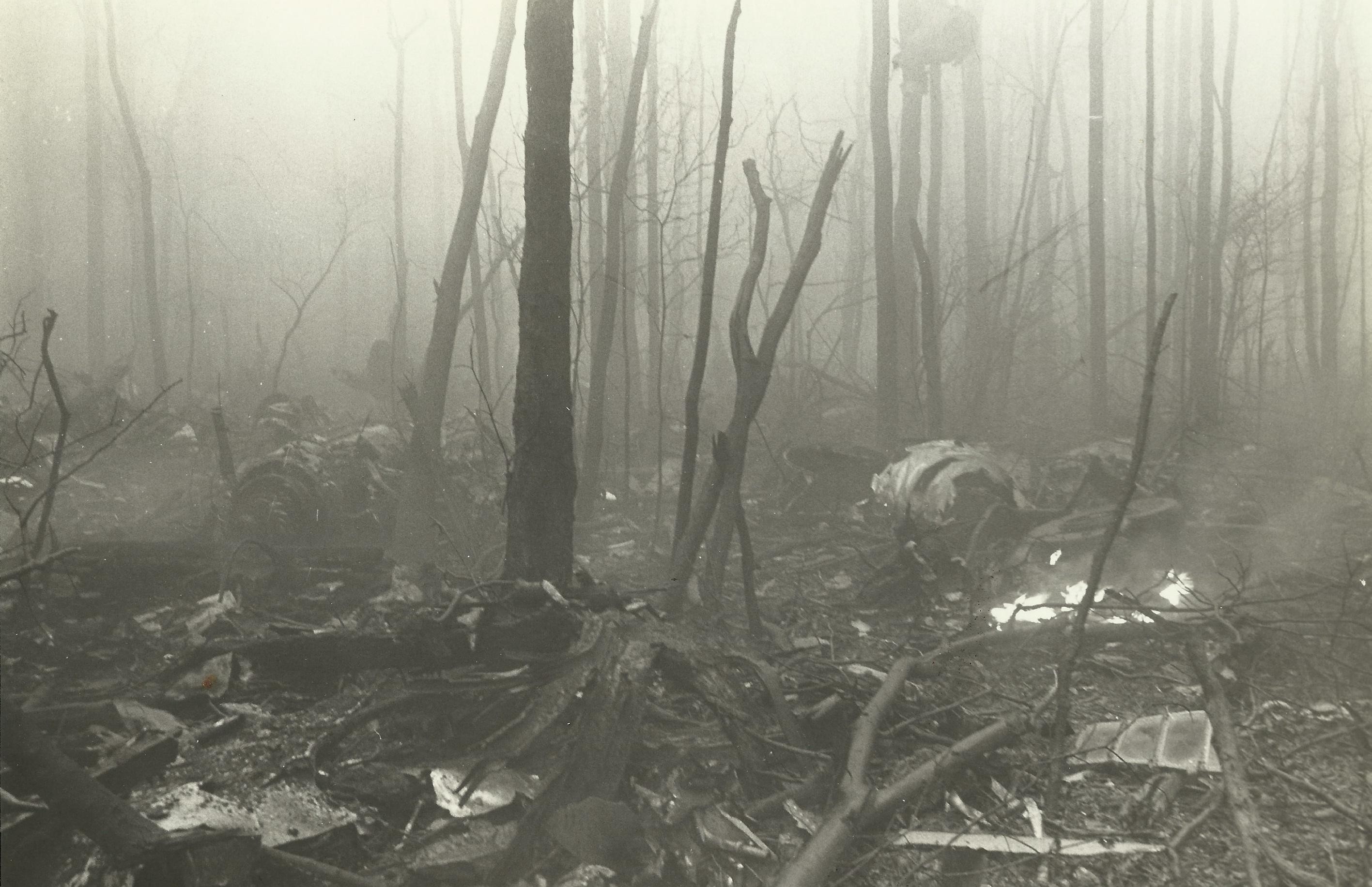
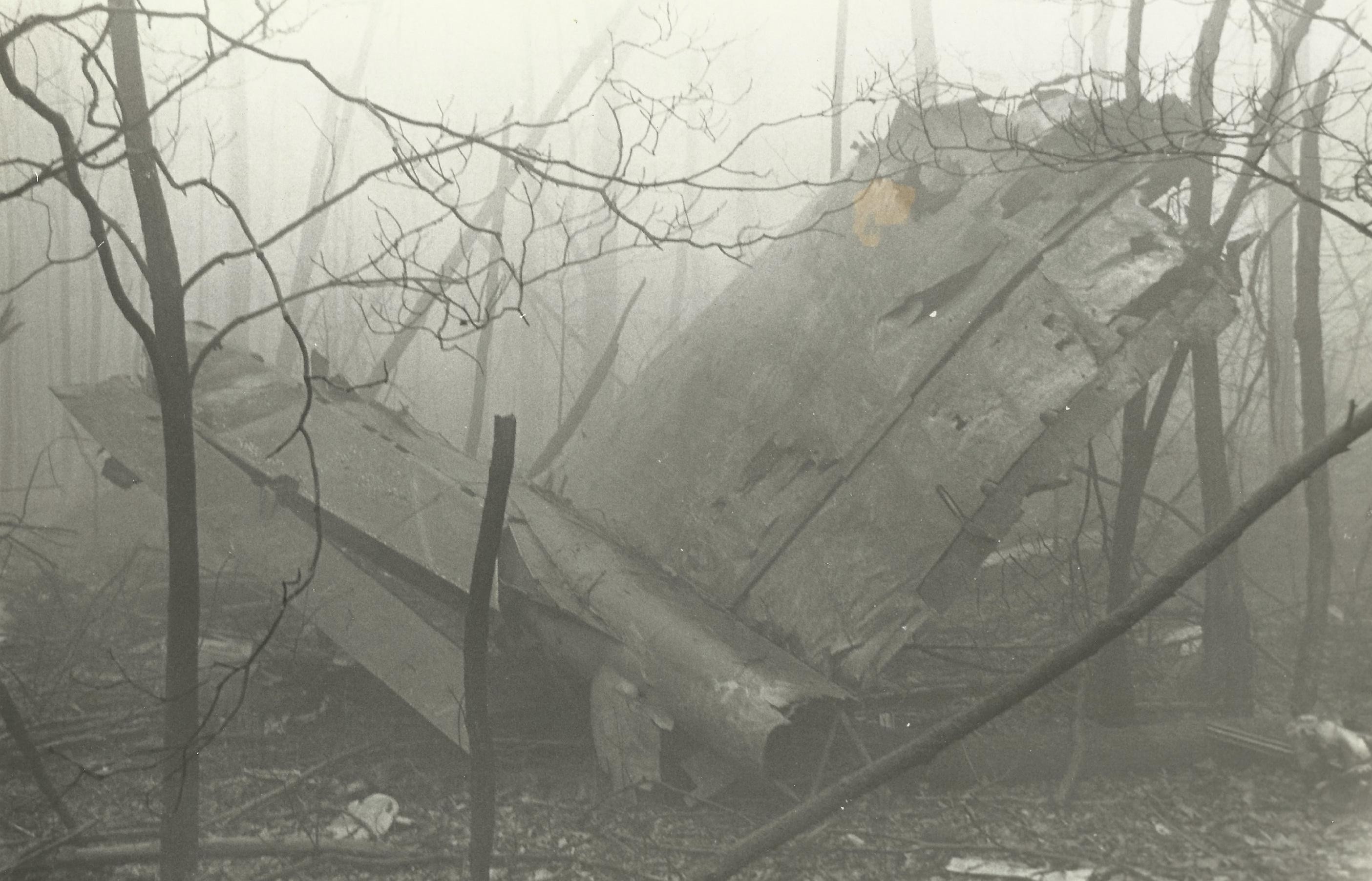
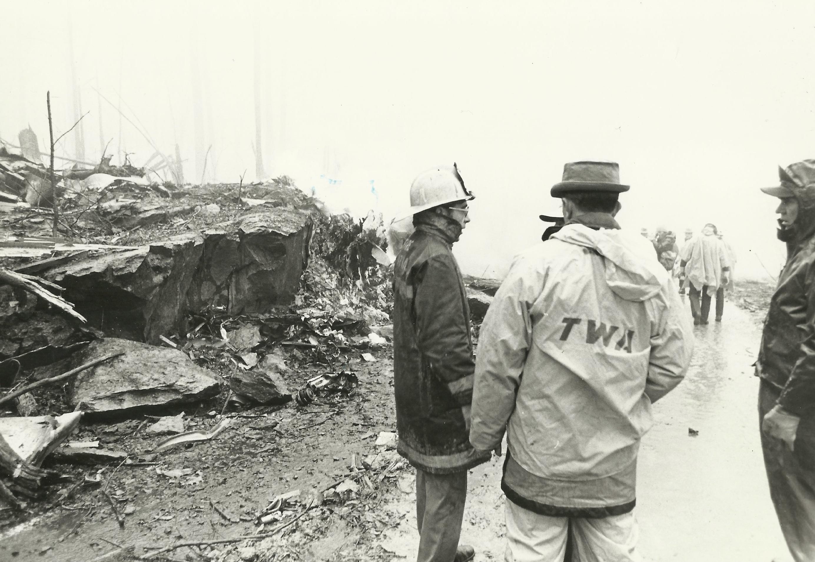
At 11:09:20, Captain Brock said, "Get some power on." The radio altimeter warning horn sounded again and stopped. At 11:09:22, the CVR recorded the sound of impact – as the airplane impacted a rocky outcropping on the west slope of Mount Weather, Virginia, at an altitude of 1,670 feet. Numerous heavy components of the aircraft were thrown forward, upward of 900 feet, of the outcropping.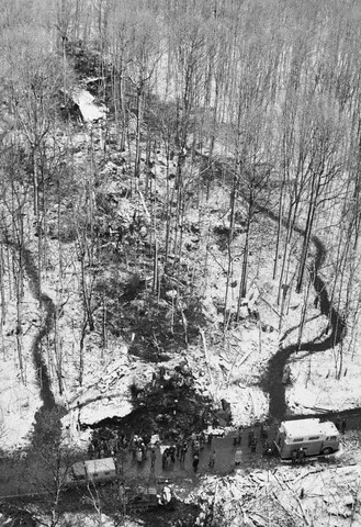
A Prompt Response...
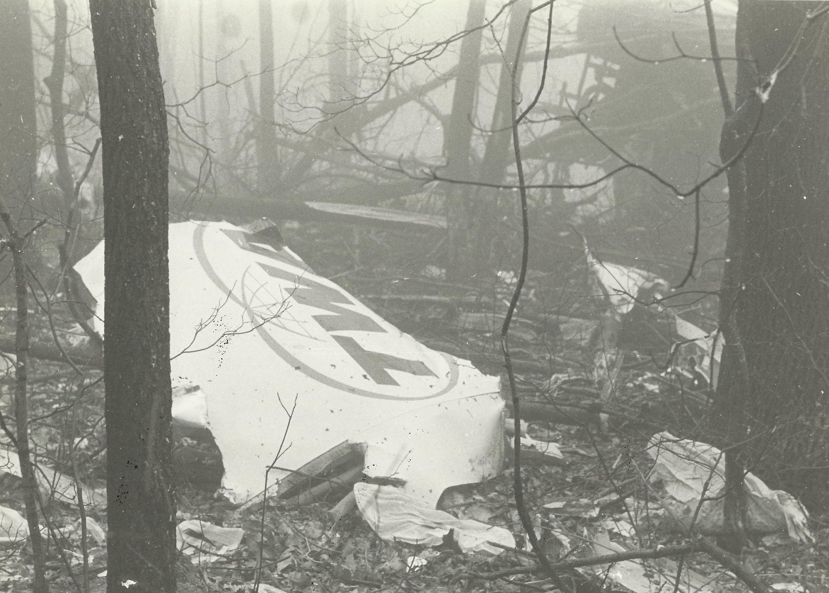
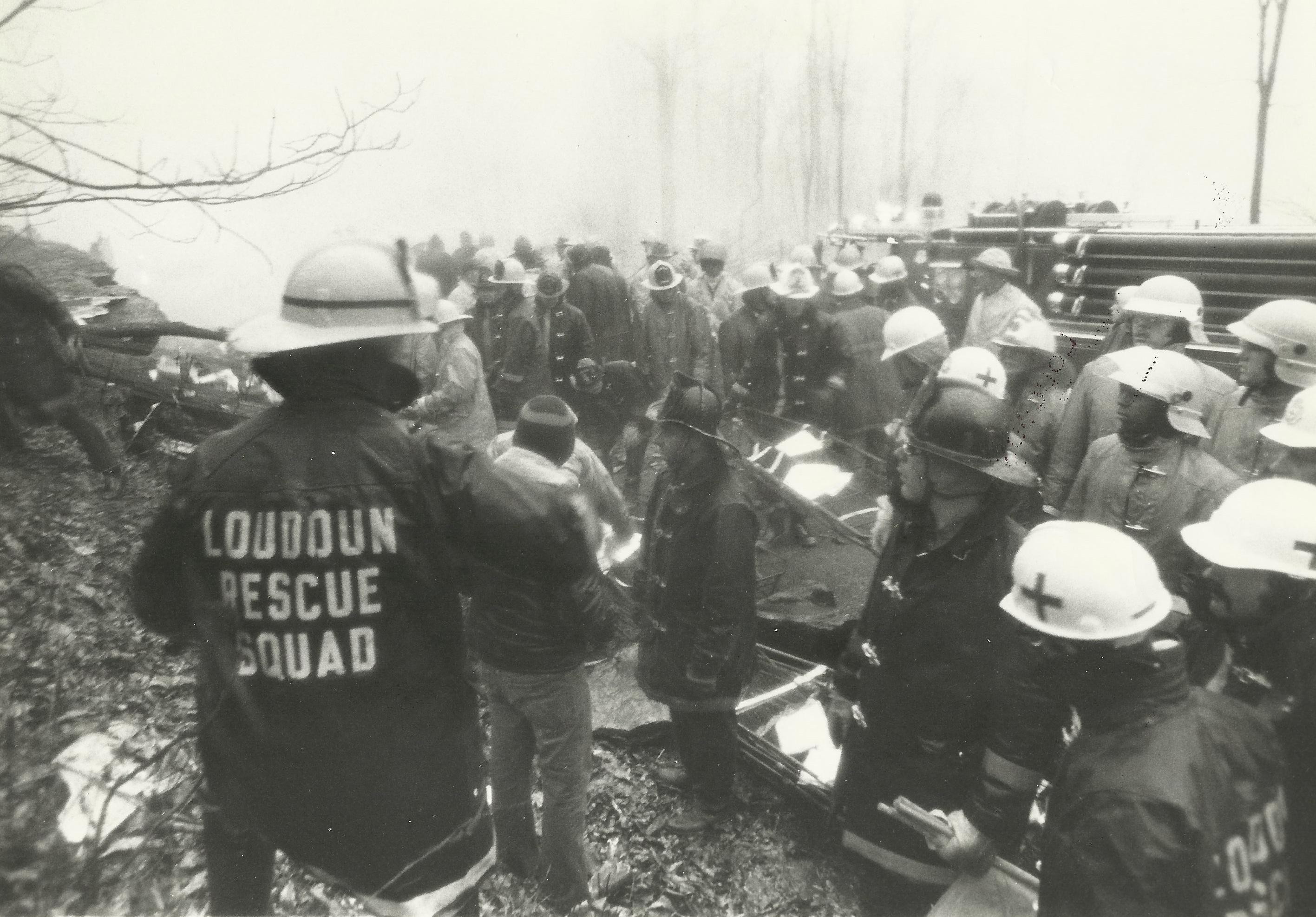
When the Dulles tower lost radar contact with the plane about 11:10 a m local authorities were notified to begin a search. Two state troopers found the wreckage almost immediately, hampered by driving ram, fog and winds gusting up to 40-50 miles an hour. Rescue workers found the woods littered with broken bodies, blazing debris and splintered timber. The only identifiable parts of the shattered silver jet were part of its tail, emblazoned in red with the letters "TWA" and one section of the fuselage with four window frames intact. Sheriff’s officers reported they had sealed the crash site on orders of Federal security agents from Mount Weather. "It looked like something out of a World War II movie," said John Emig of the Loudoun Times-Mirror, one of those who got through the picket. "As the' plane crashed it cut trees in half. All you could see were pieces of plane and trees, small fires, gray smoke and haze. It hit just west of (Virginia) Route 601, cut a swath through the trees for at least 100 yards, hit a rock bank about six feet high right at the road, and went up into the woods at least another 100 yards." A mile and a half from the crash site, the facility was not damaged, but the crash caused a temporary disruption of the Emergency Broadcast System, the Government’s network for informing broadcast stations of nuclear attacks. The plane did, however, cut power lines around the secret center of the Army interagency communications unit near the crash site, causing the teletype machines in 25 news and telephone company offices across the country to start transmitting garbled copy. Also, the facility's underground main phone line was severed, by phone service to Mount Weather was restored by C&P Telephone within 2½ hours after the crash. The flight is also of note in that it drew undesired attention to the Mount Weather facility, the then-linchpin of plans implemented by the United States to ensure continuity of government in the event of a nuclear war. A spokesman started a furor when he “politely declined to comment on what Mt. Weather was used for, how many people worked there, or how long it has been in its current use,” “People who went to the rescue noticed much more than the federal government would have preferred,” said former FEMA Director Julius W. Becton, Jr. “The rescue crews found it mighty strange that cars were parked in the middle of nowhere near the mountaintop, and that was how the cover was blown for Mouth Weather, which is a classified, underground shelter for a sizeable number of people near the Pennsylvania border.”
Investigation...
The National Transportation Safety Board’s (NTSB) accident investigation was split in its decision as to whether the flight crew or Air Traffic Control was responsible. The majority absolved the controllers as the plane was not on a published approach segment. The dissenting opinion was that the flight had been radar vectored. Terminology between pilots and controllers differed without either group being aware of the discrepancy. It was common practice at the time for controllers to release a flight to it's own navigation with "Cleared for the approach", and flight crews commonly believed that was also authorization to descend to the altitude at which the final segment of the approach began. No clear indication had been given by controllers to flight 514 that they were no longer on a radar vector segment and therefore responsible for their own navigation. Procedures were clarified after this accident. Controllers now state, "Maintain (specified altitude) until established on a portion of the approach", and pilots now understand that previously assigned altitudes prevail until an altitude change is authorized on the published approach segment the aircraft is currently flying. Ground proximity detection equipment was also mandated for the airlines.
In the end, the NTSB determined that the probable cause of the accident was the crew's decision to descend to 1,800 feet before the aircraft had reached the approach segment where that minimum altitude applied. The crew's decision to descend was a result of inadequacies and lack of clarity in the air traffic control procedures which led to a misunderstanding on the part of the pilots and of the controllers regarding each other's responsibilities during operations in terminal areas under instrument meteorological conditions Nevertheless, the examination of the plan view of the approach chart should have disclosed to the captain that a minimum altitude of 1,800 feet was not a safe altitude.
The NTSB also said contributing factors were the failure of the FAA to take timely action to resolve the confusion and misinterpretation of air traffic terminology although the Agency had been aware of the problem for several years, the issuance of the approach clearance when the flight was 44 miles from the airport on an unpublished route without clearly de- fined minimum altitudes, and the inadequate depiction of altitude restrictions on the profile view of the approach chart for the VOR/DME approach to Runway 12 at Dulles International Airport.
The NTSB’s findings were denounced by the Air Line Pilots Association, which “accused the FAA of mismanagement and said that real cause of the crash was the failure to warn the crew of the obstacle hazards.”
A Legacy of Safer Flight...
The worst air disaster of 1974, TWA Flight 514 was mentioned in the closing of the second chapter of Mark Oliver Everett's book “Things the Grandchildren Should Know ," as well as the crash, its aftermath, and its repercussions are the subject of "Sound of Impact: The Legacy of TWA Flight 514" by Adam Shaw. ," as well as the crash, its aftermath, and its repercussions are the subject of "Sound of Impact: The Legacy of TWA Flight 514" by Adam Shaw.
Massive improvements in airline safety resulted from the investigation of TWA Flight 514’s crash. The NTSB discovered that, in October of 1974 – only 6 weeks before the mishap - a United Airlines crew had very narrowly escaped the same fate, during the same approach, and at the same location.
United Airlines had, however, recently instituted a internal reporting program - the Flight Safety Awareness Program. The program encouraged crew members to report anonymously any incident they felt affected safety. The United pilots involved in the October incident reported the occurrence to their company program, and highlighted the ambiguous nature of the approach. News of the potential pitfall spread throughout United, and the FAA was notified of the situation.
However, there did not exist at the time any generally accepted method to assure the broad and expeditious dissemination of this information to flight crews and dispatchers, and the NTSB commented that, based on the United incident, and the TWA 514 accident, there was the need for a national incident reporting system. As a result, the FAA set up, under the auspices of NASA, the Aviation Safety Reporting System in May of 1975 as a confidential, non-punitive incident reporting program run by a neutral, yet governmental, third-party.
Guidelines for communication between pilots and air traffic controllers have been clarified for operating on “unpublished routes” and new pilots are drilled on what “cleared for approach” actually means. Ground warning systems that sound an alarm at higher elevations are now mandatory on carrier aircraft.
Lasting Tributes...
Two small American flags hang horizontally from a small granite plaque listing the names of the crew and passengers who died that Sunday morning.
In 1973, General "Rock" Cartwright had been a keynote speaker at a gathering of African American officers. He challenged those in attendance to continue to get to know each other, help to mentor junior officers, and help each other whenever possible. At a later meeting, the assembled group could not agree upon a permanent name. In the interest of having an identity, they called themselves “The No Name Club.” During the planning for the group’s first New Year’s Eve Party, word was received that Cartwright and his wife were both killed in TWA flight #514 crash. Before the meeting adjourned, it was agreed that the organization should be named after the General. This name "The ROCKS” was voted upon and it was unanimously agreed upon, plus that a scholarship fund be established within the group, to be named the "Roscoe C. Cartwright Scholarship Fund" in honor of his mentorship. |